National Highways advises drivers to take extra care ahead of Storm Ciarán
By Guest author 1st Nov 2023


National Highways is advising drivers to take extra care on the roads and be prepared with Storm Ciarán predicted to bring strong winds and heavy rain across large parts of the South West, South East and East regions through tonight and tomorrow.
The Met Office has issued yellow and amber alerts for strong winds and rain, with an amber alert for strong winds in place across Devon and Cornwall through Thursday morning and across London and the South East during Thursday, and a yellow alert for wind and rain across the South West, parts of the South East and East Anglia.
As a result, National Highways has issued a Severe Weather Alert for gales, with a significant risk to vehicles using the Strategic Road Network, particularly in the South West and South East regions and southern coastal areas across Dorset and Kent.
Winds are expected to strengthen in Cornwall and Devon from tonight (Wednesday) into Thursday morning, with gusts between 65mph and 75mph on higher ground, particularly on the A30 around Camborne and Bodmin in Cornwall, and other higher-ground areas in Devon, before moving across the south region and into the east, affecting counties along the English Channel throughout Thursday.
Across the remainder of the South West and parts of west Wales, wind strengths are expected to be slightly reduced, with gusts between 50mph and 60mph.
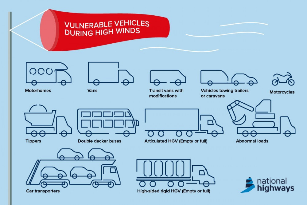
Following the alerts, National Highways is advising motorists – particularly those driving high-sided HGVs, motor homes and motorcycles, and those towing caravans and trailers – to check the weather and driving conditions before setting out on journeys and pay particular attention to exposed locations such as coastal and high lying areas and bridges which could be affected by the high winds.
Winds are expected to slowly ease during the early hours of Friday morning, although the M48 Severn Bridge, Queen Elizabeth II Bridge near Dartford, the Sheppey and Medway crossings in Kent, the bridge over the River Hamble on the M27 and the Port of Dover are likely to be affected by the strong winds during the adverse weather event, which will also bring heavy rain across parts of the south.
Amy Shaw, National Network Manager at National Highways, said: "Driving conditions are likely to change given the Met Office forecasts around Storm Ciarán. If you're using the roads slow down and give yourself more space between you and the vehicle in front. It is harder for tyres to grip the road and excess spray makes it harder to see ahead.
"We also remind drivers to remember TRIP – this is a National Highways initiative to help motorists. It stands for: Top-up - fuel, water and oil; Rest - every two hours; Inspect - tyres and lights before a long journey and Prepare - check your journey and the weather forecast before heading out.
"In high winds, there's a particular risk to lorries, caravans and motorbikes so we'd advise drivers of these vehicles to slow down and drive to the conditions.
"Drivers of other vehicles should be aware of sudden gusts of wind which can affect handling and braking, and give high-sided vehicles, caravans, and motorbikes plenty of space."
Unladen curtain-sided vehicles are particularly vulnerable to windy conditions on high ground in Devon and Cornwall, such as sections of the A30 in the Redruth area and Bodmin, and across southern coastal areas.
Amy added: "Curtains on empty high-sided vehicles can act as sails when closed, and when high winds arise, we advise HGV drivers to open their curtain-sided vehicles if they are empty."
Met Office Chief Meteorologist Dan Suri said: "Wind and rain warnings associated with Storm Ciarán are in force from Wednesday night onwards into Friday.
"An amber warning for winds is in place for south western parts of England and Wales in the early hours and morning of Thursday and the far south and south east of England Thursday daytime and early evening.
"Storm Ciarán is expected to bring very strong winds along southern coastal areas of England in particular where gusts of 70 to 80mph are possible, gusts perhaps exceeding 85 mph in the most exposed locations. Further inland, gusts could reach up to 50 or 60mph.
"As well as strong winds, this deep low pressure system will bring heavy rain to many parts of the country. The rain will fall on already saturated ground, bringing the risk of flooding."
National Highways has produced online guidance on its website for driving in different weather conditions in an effort to keep road users as safe as possible on its motorways and A-roads.
While rain is frequent throughout the year, it is particularly common over the autumn and winter months, with the possibility of floods, slippery road surfaces and reduced visibility for drivers.
In heavy rain, drivers should keep well back from the vehicle in front, gradually ease off the accelerator if the steering becomes unresponsive, and slow down if the rain and spray from vehicles makes it difficult to see and be seen.
National Highway driving tips
There are lots more travel tips, vehicle checks and useful motoring advice for negotiating severe weather on the National Highways website, to help improve driver confidence when travelling as temperatures get colder, the nights draw in and the potential for fog, rain and high winds increase.
Don't drive through flood water: there could be hidden hazards, and it may be deeper than it looks.
The following advice will help you stay safe when driving in wet weather:
- If it's time for your wipers, it's time to slow down
- Use dipped headlights, especially if visibility is seriously reduced
- The roads will be more slippery than usual, so give yourself more time to react - increase the gap between you and the vehicle in front to at least four seconds
- Look out for standing water - adjust your driving before and after encountering any
- Always keep your eyes on the road - spray from other vehicles can suddenly reduce your visibility
- Visibility affects others too, so anticipate their actions and be prepared
- During thunderstorms, sudden winds can unsettle vehicles - keep your speed down and give other road users more room
If your vehicle is susceptible to high-wind conditions, consider delaying your journey until weather conditions improve if you can.
- Slow down and keep focused on the road ahead – you may encounter debris blown in by the wind
- Avoid using exposed sections of road if possible. Lorries, caravans and motorbikes are at particular risk.
- Use both hands on the steering wheel to keep good control of your vehicle -gusts of wind can cause your vehicle to shake
- Look out for gaps in trees or buildings, or when crossing bridges – you're more likely to encounter side winds here
- Keep room on either side of your vehicle to allow for it being blown sideways
- Watch out for side winds when passing larger high-sided vehicles - keep room on either side of your vehicle to allow for it being blown sideways
Minor roads are more likely to be obstructed by fallen branches and debris, so keep to main routes if you can.
In the meantime, drivers are being advised to follow messages on any overhead signs, listen to radio updates and follow the National Highways' Twitter feeds @HighwaysSWEST and @HighwaysSEAST. Further information can be found at www.trafficengland.com or calling the National Highways Information Line on 0300 123 5000.
CHECK OUT OUR Jobs Section HERE!
midsomernorton vacancies updated hourly!
Click here to see more: midsomernorton jobs
Share:


